Bus route cuts and bus stop changes

Bus company @Stagecoach_Ox has announced changes to its services following the County Council’s cuts to bus subsidies. Here are the changes that will affect routes serving Headington and Marston. They take effect on 21 July 2016.

The 17A and 17C services will stop running. These currently connect the main railway station via Jericho and Marston to the JR Hospital.

There will also be changes to the 14 and 14A services between the station, Marston and the JR. Stagecoach say “There will be additional evening journeys on service 14 from JR Hospital with a last departure at 2105 and from the City Centre with a last departure at 2130 hours, Mondays to Saturdays. There will also be some changes to daytime journeys on the 14/14A.” The new timetable for these routes is here.

For more information see Stagecoach’s full announcement covering all of its affected routes. Oxford Bus Company routes aren’t changing

In other bus news, some routes serving Headington from the city centre will be affected by the closure of Queen Street to all vehicles from Monday 6 June until November. This means you might have to get on or off your bus at a different or new stop.

The 8 and 9 services will not go to or from Castle Street. From Headington you will still be able to get off at the top of the High Street or on Speedwell Street, but leaving the city you will need to use Speedwell Street or a new stop (labelled G0) on St Aldates.

Headington-bound U1 and 280 services will continue to stop on Park End Street and at new stops on Castle Street before going on to the top end of the High Street as now. Westbound the U1 will stop on St Aldate’s and the 280 at the top of the High Street. Both will stop on Norfolk Street (before Castle Street) before continuing towards the station.

As well as stopping on New Road as now, the Headington-bound 400 will stop on Castle Street before stopping again on St Aldates, but it will no longer stop at the top of the High Street. In the other direction the stops will be at the top of the High Street, Speedwell Street and Castle Street.

There’s a rather messy but comprehensive map showing the stops for all services here.
London Road cycle provision

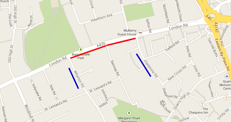
Oxfordshire County Council’s proposals for a cycle track on the south (inbound) side of the London Road between Gladstone and Wharton Roads goes to the Cabinet Member for the Environment David Nimmo Smith @DNimmoSmit1 on Thursday 27 February. The officers’ report on the proposals recommends approval.

There has been some consultation on the scheme and local councillors have tried hard to influence the outcome. How successful they have been isn’t clear from the report. If you haven’t been following the story closely the details in the report – especially the impossibly small and undetailed ‘technical drawing’ – are too sketchy for you to really understand the proposals.

Under the scheme there will be a segregated footway/cycleway on the south side of the London Road. Most people prefer this to the shared use solution. However, it won’t be segregated all the way from Gladstone Road to Wharton Road. “Most of the route will be segregated with some small stretches un-segregated due to narrower footway widths” (Annex 2, Officer comments no. 3). The report doesn’t show where the unsegregated sections will be.

Two other points of concern have NOT been addressed. The cycle route crosses Ramsay Road using a “raised junction treatment”. The critical issue here is how the junction will be marked. To allow cyclists as safe and uninterrupted a journey as possible, and recognising they are on a main road crossing a side road, the junction should be marked with Give Way lines and signs on Ramsay Road which give priority to the London Road cyclists. Whether this is intended is not stated: indeed the very last entry in Annex 2 is the only blank box in the ‘Officer comment’ column.

Similarly the treatment of the end of the cycleway at Wharton Road is important. Earlier versions of the scheme had cyclists arriving at Wharton Road with no particular provision for them to join the main road safely. In Annex 2 you will now find “By ending the facility at this junction it gives cyclists the opportunity to re-join the carriageway at a point where there is an advisory cycle lane marking.” How this is achieved will be a critical feature, and it is not too late for the Council to add some protective road markings on the main road.

As for the rest of the report, it’s notable for its sloppiness. The cyclability audit (para. 3) was about Headington roundabout to the NOC, Churchill and Old Road campus. It’s irrelevant to this scheme. The report has discovered a whole new campus too, the ‘Old Headington campus’ (para. 5). It makes a big thing of the success of the OxonBikes scheme – at best a dubious claim given the failure of the company running it, and with no real assurance other than a hope that a successful replacement operator can be found.

It seems likely the scheme will be approved. Let’s hope local residents and Councillors can hold the officers to their promise that “more input will be sought during the detailed design(para. 15).

Report Published

I have received a copy of the Consultants’ report on the Headington Transport Strategy. It is in two parts, which you can download from the links below. I haven’t had time to absorb it yet but first impressions are that it describes the present situation rather than setting out a strategy for dealing with the acknowledged problems. Indeed, the main report describes itself as a “Baseline Conditions Report”. There’s plenty of tables of data and quite a few maps: how up-to-date and reliable I can’t yet say.

As far as I know the County Council has not yet announced any public consultation on the report. I will post more on this when I can.

Download:
Baseline Conditions Report Jan 2014 (6.31Mb pdf)
Growth Pressures & Appendices Nov 2013 (672Kb pdf)