Barton Area Action Plan

The plan to build more than 1000 homes in what has become known as West Barton (or sometimes Barton West) is set to become one of the big issues in Oxford over the next few years. The Barton Area Action Plan (BAAP) was approved by the City Council in December 2011 and the latest version of the plan will be out for public consultation soon.

Understandably the Council stress they want to build a new community which will be as fully integrated into the rest of the City as possible, but this presents several difficult problems. The A40 forms a barrier between West Barton and the areas inside the ring road, Old Headington and Northway. Access, new links, provision for public and private transport, all have to be debated and the best solutions found. Top of the agenda at the moment is the proposal to make the section of the A40 between Marston and the Green Road/Headington roundabout an ‘urban boulevard’. This means reducing the speed limit to 40mph which, it is claimed, makes it possible for houses to face the road rather than have their fronts facing into the development. The Chairman of the Oxford Civic Society, Peter Thompson, has written about this in a letter to the Oxford Times this week in which he says it will need “more than just speed limit signs” to achieve the desired results.

I am not taking issue with Mr Thompson; his letter is perfectly reasonable. The problem I have is that when feelings inevitably run high, claims and counter-claims are made by supporters of one or other approach to these development problems. Unsubstantiated assertions about what should or should not be done are made, but no supporting evidence is ever given. This may be because there is no evidence, although I suspect that there may be some in the planning literature.

Would the ‘urban boulevard’ be the first in the country? In Europe? If so we need to know that it is untried and untested, so the outcome will be highly uncertain. It might work, or it might not. Or has it been tried before? If so, was it a success or a failure? There must be case studies and examples we can look at to help us decide. So far all I have seen are comments about Sunderland Avenue: some say it should not be seen as a template for West Barton, others cite it as an example of the idea in practice. What we have is plenty of noise (sorry, no pun intended!) but little information.

So my plea is this: can the planners and others who want to contribute to the debate give us whatever evidence they have in support of their positions. Let’s have relevant examples of successes (and failures). If there is no evidence, say so: opinions are perfectly valid but knowing what has worked and what hasn’t is far more helpful. The opportunity to create an important new Oxford community (and to regenerate ‘Old Barton’) is too important: we need to give it the best possible chance of success.

The Council’s web page about the BAAP is here, where you can also download the latest version.
Headington Headlines #44

Here’s my weekly round-up of local news for 2 – 8 January —

The Christmas tree outside Barclay’s Bank blew over in the strong winds overnight on Monday/Tuesday.

A planning application was submitted which could see a Sikh temple established on the London Road near the corner of Northfield Road.

A taxi driver was robbed on Hollow Way in the early hours of Monday morning, and a 22-year old man from Slade Close was convicted of robbery and sentenced to 40 months imprisonment. One of his offences taken into account was the theft of a puppy.

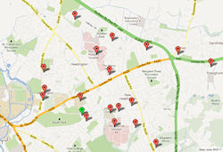
The locations of the possible Sikh temple and Slade Close are shown on this map.

Headington car park is to have handrails installed to improve disabled access from the car park to Waitrose. @OxfordCity and @WaitroseUK have jointly funded the cost.

The BBC televised the morning service at All Saints’ Church, Lime Walk on Sunday.

I made a map of all the sites in OX3 in the City Council’s Sites and Housing document which sets out approved forms of development. I think it’s easier to use than the original document. Consultation on the latest version starts soon.

Active topics on the Headington & Marston e-democracy forum this week:

  • Sikh temple in Cherwell Drive
  • Certifying documents
  • Headington & Barton bus service
  • Shocking acknowledgement of the extent of the housing crisis in Oxford

I try to cover news from the OX3 postcode in Headington and out as far as Barton, Sandhills and Risinghurst (see map). To feed into next week’s summary you can comment on this article, or tweet either with the hashtag #ox3 or @mentioning @TonyOX3.

Future Development in OX3

One of the big issues in Headington in 2011 was the City Council’s proposals to build over the car park in Headington. This was just one of scores of proposals for the future of sites all over Oxford driven by the need to identify places where much-needed housing can be built. The proposals formed the Sites and Housing – Preferred Options document which went through an extensive public consultation during the year. One welcome result was the abandonment of the Headington car park proposal.

The Sites and Housing Development Plan Document (DPD) was considered by Oxford City Council on 19 December 2011 after the results of the consultation exercise had been analysed. The amended DPD will be open for a six week public consultation early in 2012 before being submitted to the Secretary of State for Communities and Local Government. An enquiry under a Planning Inspector may follow.

A revised version incorporating any changes made at the Council meeting has not yet been published, so this post is based on the paper which was debated on 19 December. The document is not easy to navigate in digital form. The details about each site are in Section B2 of Appendix 3 of the paper: the SP number against each site is that site’s Site Allocation Policy number. These SPs set out the type of development it is proposed should be allowed on the site and any conditions that apply. The Barton West development is NOT included in this document.

Sites in Headington

I have extracted all the sites which lie within the OX3 postcode area and shown these on a Google map. I’ve given the benefit of the doubt to the BT site on Hollow Way which I think is partly in OX3. Clicking a marker on the map shows the Site Allocation Policy for the site. I have also given the paragraph numbers in the full document (eg B2.22-24) where each site is discussed, and the page number in the pdf document from the Council’s agenda papers (eg PDF pp 26/27). These page numbers are not the same as the numbers in the DPD itself. At the bottom of each box which appears when you click the marker is a link to a short pdf file which I have extracted from the full document and which contains the whole section dealing with the site. [NB: Some of these extracts cover more than one site, so scroll down if you don’t immediately see the one you’re looking for.]

I hope you find this form of presentation easy to follow, and I’d be happy to have your comments.

As well as development policies for specific sites the DPD also contains general policies on housing matters which could affect planning decisions and development in the City for many years – worth reading if you’re interested in these things.