Life in and around Headington & OX3 (mostly), and Oxford (occasionally)
"To every complex problem there is a simple solution, startling in its simplicity, piercing in its clarity, and hopelessly and completely wrong" - Gore Vidal.
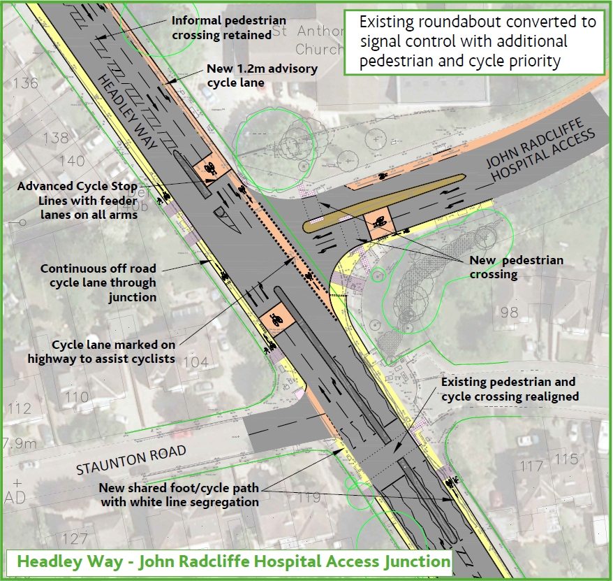
The next phase of Access to Headington work covers Headley Way and Cherwell Drive. It includes remodelling the junction at the JR access, where the mini-roundabout will be replaced by traffic lights. At the bottom of the hill the whole junction will be altered with lights replacing the double roundabout. The one-way flow on the service road outside the shops will be reversed.
More-or-less continuous cycle paths will be created on both sides of Headley Way and Cherwell Drive. Although there are significant shortcomings in the design, which is regrettable, cyclists should find their journeys feeling safer and more comfortable.
Site equipment will start appearing on 19 June with construction beginning a week later. This will be at the JR entrance junction and will include the junction of the lower (Jack Straw’s Lane) part of Staunton Road with Headley Way. The work here and elsewhere will continue until about the third week of October, when it will be suspended until restarting at the beginning of January 2018. A detailed schedule of planned dates for the whole project is not yet available.
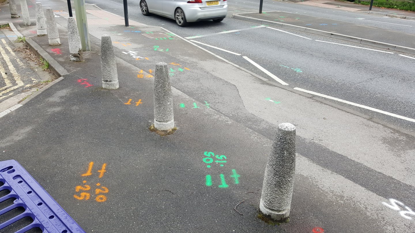
These marks can only mean one thing – roadworks!Work starts here 19 June.
The Jack Straw’s Lane section of Staunton Road will be closed for about three weeks while the work is happening.
At present, motor vehicles leaving this part of Staunton Road wanting to turn right on Headley Way have to turn left and make a U-turn round the mini roundabout. Once the roundabout has been replaced by traffic lights this won’t be possible; there’s no obvious alternative.
I made a few notes on the plans when I went to the open exhibition in Northway on Monday, concentrating on the cycling aspects. I’ve passed them to the County’s Access to Headington team and you can read them here. I understand Cyclox will be sending some more comprehensive comments.
You can find the engineers’ drawings here. In the sidebar to the right of this post are links to the County’s website for the project and for signing up to their regular newsletter about the scheme.
This arrived from the County Council a few days ago in the wake of the exhibition of plans held on 23 March.
Work on the next phase of the Access to Headington transport improvement scheme will start soon. The next phase will focus on The Slade, between Old Road and the mini roundabout at the junction of Hollow Way/Horspath Driftway.
Contractors working for the county council will set up the site from Monday 10 April with construction work set to start on Tuesday 18 April.
Setting up the compounds will be done off-peak to reduce any impact on traffic and so that noise and disruption whilst units are installed and operated can be kept to a minimum.
This section of work will take approximately 26 weeks to complete. The team will do all they can to minimise delays but people travelling in the area are advised to plan their journeys.
Last week I had a moan about the new cycle route signposts installed at the Gipsy/Warneford/Roosevelt/Old road junction, complaining that they were set too high for cyclists to see them. This sparked quite a debate on twitter, with some people saying it was ‘the regulations’ and me asking for chapter and verse.
I can’t believe I’ve been spending time on this, but here’s what I’ve found out.
The definitive source of everything statutory about road signs is the Traffic Signs Regulations and General Directions 2016. Astonishingly for such a vast and comprehensive document, it is silent (as far as I can find) on the matter of height above ground.
The Traffic Signs Manual is intended to give advice to traffic authorities and their agents on the correct use of signs and road markings. Mandatory requirements are set out in the current version of the Traffic Signs Regulations and General Directions; nothing in the Manual can override these.
The Manual comes in several chapters. Chapter 2 (Informatory Signs) would appear to be the relevant one, but it is still in draft. However the Manual web page for this chapter says
The current advice on the design and use of directional informatory signs is published in Local Transport Note (LTN) 1/94.
So (noting it’s 23 years old) I went to LTN 1/94, only to find that it too is silent on the question of mounting height.
But back in the Traffic Signs Manual I found that both Chapter 3 (Regulatory Signs) and Chapter 4 (Warning Signs) do have something to say. In Ch.3 1.21 and Ch 4 1.24 I at last found this:
MOUNTING
The normal mounting height measured to the lower edge of a sign or backing board (or any supplementary plate) is between 900 mm and 1500 mm above the carriageway alongside. The greater height should be used where vehicle spray is likely to soil the sign, or above planted areas. Careful consideration should be given to any proposal to mount signs at a low height, such as on railings or bollards, as there is a risk of drivers not noticing them, especially at night or when they could be obscured by parked vehicles or pedestrians. Where signs are erected above footways, or in areas likely or intended to be used by pedestrians (e.g. pedestrian refuges), a headroom of 2300 mm is recommended, with 2100 mm as an absolute minimum. A clearance of at least 2300 mm should be maintained over a cycle track or shared cycleway / footway.
This must be where Sustrans get their recommendations from. In their handbook “Cycle Network Signing” (July 2013) they say
4.2 Carriageway and cycle path signs should normally be set back to give a clearance of at least 500mm from the edge of the carriageway or cycle path. Where signs are located closer to or on a cycle route, they reduce the effective path width available for cyclists.
The best level to fix a sign in the verge for visibility by cyclists is between 900 and 1500 mm off the ground, although care must be taken not to obstruct the visibility of children on footways adjacent to highways with low level signs. Mounting a sign at this level however reduces its visual intrusion. However, where signs might overhang cycle or walking routes, the mounting height should allow a minimum of 2.1m clearance for pedestrians and 2.3m for a cycle track. The minimum clearance for equestrians is 3.4m. Mounting heights should also have regard to possible vandalism and theft – higher posts are recommended where such problems are expected. p.31, with thanks to @SafetyG1rl for the reference.
To see if there is any research to justify the 2.1/2.3 metre policy and its implications of head-banging cyclists and pedestrians I searched the publications of TRL, the now-private company that used to be the Transport and Road Research Laboratory (TRRL). I found nothing. It just seems to have worked its way into the system, probably by a route invoking Health & Safety.
Where does this leave us? The 2.1/2.3 metre standard for signs over a footway or cycleway seems to be advisory rather than statutory, but I imagine it would be a brave highways engineer who did something different. But there is no reason why cycle route signs which don’t overhang walking or cycling paths shouldn’t be lower; Sustrans’ 0.9 – 1.5 metres above ground for example. It means wherever a new sign is needed an effort should be made to find a location which would allow the lower height option. Cycling signs higher than two metres should only be used when there’s no alternative.
So here is my message to the highway engineers working on the next phases of Access to Headington: take the time to look around, be imaginative, and see if you can’t find a way to do this.