Possible Development Sites in OX3

As I mentioned in early July (HH324) Oxford City is consulting on the ‘Preferred Options’ stage of the City’s developing Local Plan covering the period up to 2036. The consultation runs until 25 August. If you need to catch up try the Council’s Local Plan web page and @OxCivicSoc‘s short article. You can download the full Preferred Options document here.

Section 9 of the document  is headed ‘Sites’. It starts with this explanation:

A site allocation is a planning policy that describes what type of land use, or mix of uses, would be acceptable on a specific site or whether the site is protected for certain types of development. The purpose of the site allocations is to allocate sites for built development or to maintain a type of built development on a site. Site allocations are important because they give guidance and certainty to developers and landowners and they help local people understand what may happen in their neighbourhood in the future.

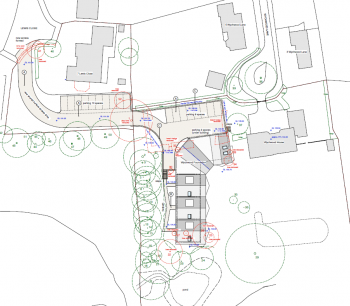
Two poor quality maps show (1) sites that have been rejected as unsuitable for development for a variety of reasons, and (2) sites that may have development potential subject in some cases to further investigation. Each map is followed by a table identifying the sites shown on the map. This is the map of ‘Sites recommended for further investigation’.

Sites recommended for further investigation

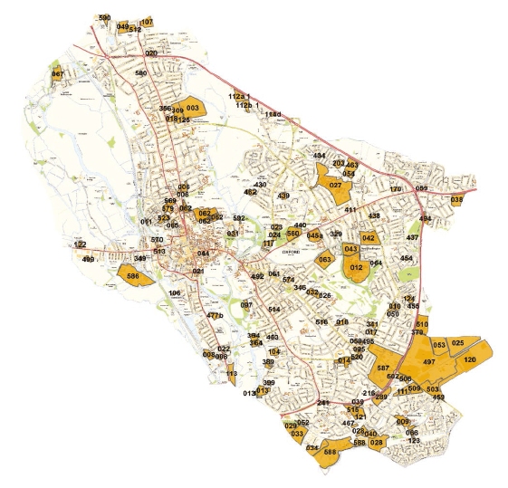
I’ve used the map and the tables to make a more useful map showing just the ‘further investigation’ sites in OX3*. I’ve placed the markers as best I can but I can’t guarantee that I have all of them spot on. The same goes for the postcode you’ll see among the data from the tables when you click on a marker – the Council doesn’t give a postcode so I’ve used one that’s close by as a means of getting the marker on the map.


It’s best to click on the icon at the right of the header bar to make the map full-screen.

As always, it’s worth taking the time and trouble to pass on any comments you have on this or any other part of the Preferred Options. Various ways of doing this are on the Council’s Local Plan web page whose link is at the top of this article.

* I’ve left out a few commercial sites outside the Ring Road which are technically in OX3.

Don’t mention Barton

This story was first published in HH 326 on 17 July 2017.

Now here’s a strange thing. The first houses being built in @BartonPark_ are being marketed under the name “Mosaics Oxford”. The marketing campaign has emerged on twitter as @Mosaics_Oxford and they have a website which was first registered in April last year — mosaicsoxford.co.uk.  The copyright tag on the website shows that Mosaics is another face of the builders of Phase 1, Hill. Mosaics Oxford is, they claim, a “vibrant new community”, “nestled next to Oxford’s bustling city centre”. Devoted readers will recall that an important selling point of Barton Park was how the new development would integrate with existing Barton to their mutual benefit. Strange then that the word ‘Barton’ (with or without the ‘Park’) doesn’t appear anywhere in Mosaics’ sales pitch. The street address of the marketing office (or ‘suite’, as they prefer to style it) is just a postcode which places it in St Aldates.

Border Skirmish in Narnia

Battle lines are being drawn up over a planning application in Risinghurst. The application (ref: 16/02549/FUL on the Council’s website) is to build

“4 x 3-bed, 3 x 2-bed and 2 x 1-bed apartments. Provision of amenity space, 22No. car parking spaces and cycle store. Formation of new vehicular access from Lewis Close. [on] Land Adjacent 4 Wychwood Lane Oxford OX3 8HG”

People are concerned about issues of access, traffic and more, but perhaps the most emotional reason for local opposition is that the site is right against the boundary of the C S Lewis Nature Reserve, a space that is much-loved, even treasured, by local people and admirers of the author and his works from all over the world. The proposed access road to the buildings starts at the top of Lewis Close directly opposite The Kilns, Lewis’s house in Risinghurst.

Site plan for the development

The Planning statement says “The proposal is made on behalf of the Wychwood Foundation, a charitable Trust.” This is not strictly true, as the Wychwood Trust does not exist as any recognised entity. It is not a registered charity or a limited company. However, among the planning documents on the Council’s website is a statement by the Foundation over the signatures of Jonathan and Sarah Beecher of 4 Wychwood Lane – the same address as the planning application so presumably the owners of some or all of the land. In their introduction they say “The aim of the Wychwood Foundation is to look after people who are vulnerable, and to give them a sense of happy and supportive community.”

Despite not being a registered charity the applicants are asking for the statutory exemption available to charities from the CIL contributions developers normally have to pay. The CIL (Community Infrastructure Levy) is the route by which local councils get money for providing infrastructure services (drainage, street lighting, refuse collection etc.) I have no experience of dealing with the Charity Commission, but it seems very unlikely that the Beechers will be able to satisfy the Charity Commissioners of their genuine charitable purposes and achieve registration in time for their application to be dealt with.

I notice that a Jonathan Beecher is the Director of Beecher Acoustics Ltd, whose registered address is 1 Quarry High Street. This company says its Nature of Business is “Manufacture of musical instruments, Repair of other equipment, Buying and selling of own real estate” – that last phrase seeming to cover the development in question if it is indeed the same person. The architectural drawings were drawn up by another Beecher based in Edinburgh.

The elevation drawings show a terrace of three storey buildings with steeply pitched roofs accommodating the top storey. The buildings are partially sunk below the ground level of part of the site. I’m sure the plans will be examined in great detail by all those who fear the impact the development may have on the local scene.

East and south elevations
North and West elevations

I should mention that there is a petition calling on the Council to reject the application – follow the link. As I write it has attracted 3570 signatures.

Footnote: I asked the applicants’ agents for a comment on the charitable status they are claiming on behalf of their clients but have had no reply. Documents shown or linked here were downloaded from the Council website on 25 and 27 October 2016 and archived on my website. Beecher Acoustics information from Companies House website 25 October 2016.