Possible Development Sites in OX3

As I mentioned in early July (HH324) Oxford City is consulting on the ‘Preferred Options’ stage of the City’s developing Local Plan covering the period up to 2036. The consultation runs until 25 August. If you need to catch up try the Council’s Local Plan web page and @OxCivicSoc‘s short article. You can download the full Preferred Options document here.

Section 9 of the document  is headed ‘Sites’. It starts with this explanation:

A site allocation is a planning policy that describes what type of land use, or mix of uses, would be acceptable on a specific site or whether the site is protected for certain types of development. The purpose of the site allocations is to allocate sites for built development or to maintain a type of built development on a site. Site allocations are important because they give guidance and certainty to developers and landowners and they help local people understand what may happen in their neighbourhood in the future.

Two poor quality maps show (1) sites that have been rejected as unsuitable for development for a variety of reasons, and (2) sites that may have development potential subject in some cases to further investigation. Each map is followed by a table identifying the sites shown on the map. This is the map of ‘Sites recommended for further investigation’.
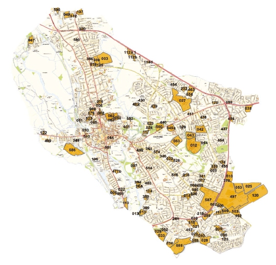
Sites recommended for further investigation

I’ve used the map and the tables to make a more useful map showing just the ‘further investigation’ sites in OX3*. I’ve placed the markers as best I can but I can’t guarantee that I have all of them spot on. The same goes for the postcode you’ll see among the data from the tables when you click on a marker – the Council doesn’t give a postcode so I’ve used one that’s close by as a means of getting the marker on the map.


It’s best to click on the icon at the right of the header bar to make the map full-screen.

As always, it’s worth taking the time and trouble to pass on any comments you have on this or any other part of the Preferred Options. Various ways of doing this are on the Council’s Local Plan web page whose link is at the top of this article.

* I’ve left out a few commercial sites outside the Ring Road which are technically in OX3.

Headington Headlines #330

A relatively quiet week of local news for 7 – 13 August.

The County Council is resurfacing the A40 Northern Bypass, with the road being closed at various times including over the weekend just gone and during this current week. The County’s description of the works is far from clear, with Sunderland Avenue and North Way both being mentioned. It is not clear whether the whole road from Headington roundabout through Sunderland Avenue to the Wolvercote roundabout is affected. Their description of work to be done this week reads:

A40 North Way will be closed at night between 7pm and 6am each night from Monday 14 August to Friday 18 August. The noisiest operations will be completed by 11pm each night. The road will be open during the day over this phase.

They also say:

A40 Sunderland Avenue will be closed at night between 7pm and 6am each night from Monday 14 August to Friday 18 August. The noisiest operations will be completed by 11pm each night. The road will be open during the day over this phase.

Make of it what you will. The relevant web pages are here and here.

Good news for community groups left with nowhere to meet by the temporary closure of the Bullingdon Centre in Peat Moors. The Council are installing safety props and the building could reopen by the end of the month.

The Oxford Mail carried a story on 29 High Street implying there might be some movement on the planning stalemate that has kept it derelict for many years. But there doesn’t seem to be anything new in the report, so personally I’ll be surprised if anything happens in the near future.

Active posts on the Headington & Marston e-democracy forum this week:

  • Extending Early Bird Discount Chinese Classes

Headington Headlines #329

Your weekly round-up of local news for 31 July – 6 August.

Black Mamba Tattoos in Windmill Road has moved into the nearby Vente Hairdressers.

News broke on Tuesday that the Trauma Unit at the JR was unsafe if a fire broke out. There are several problems including, inevitably, the cladding. The Trust decided to evacuate the building and move patients and beds elsewhere in the hospital. This was completed by the end of Friday afternoon.

Connor Sparrowhawk’s mother’s personal details were leaked to medical staff facing a tribunal to decide if any of them were at fault over Connor’s death.

Barton residents are being offered a free course in video production and the chance to make a film about how they travel around the local area.

Some properties in Colwell Drive, Barton were evacuated on Thursday after a tree fell on a house. Luckily no-one was injured.

Bury Knowle Park is one of 6 Oxford Parks to be awarded a Green Flag this year.

I made a map of all 729 HMOs in OX3 (HMO = house in multiple occupancy). It’s taken from Oxford City’s published register dated 21 July 2017. Go on, take a look!

Active posts on the Headington & Marston e-democracy forum this week:

  • I see stagecoach has published a bus road design guide
  • Local Plan 2036