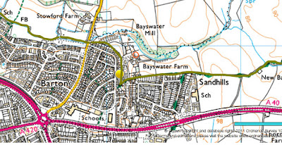
News broke yesterday that South Oxfordshire District Council (SODC) is considering land at Bayswater Farm on the edge of Barton for housing development. The story seems to originate here, a news release from SODC in mid-June. It explains that their plans to meet new housing requirements partially from ‘windfall’ sites were thrown out by a planning inspector so they have had to look again at where 800 new homes that they had allocated to unspecified windfall sites could go. Under the broad heading ‘larger villages’ the phrase ‘land at Bayswater Farm’ is included. The changed strategy went before a full Council meeting on 30 June – the minutes don’t seem to be online yet, but I believe the Council did approve the revised strategy.
Local people are very aware of Oxford City’s proposed expansion of Barton, but probably not many realised that SODC’s boundary came so close. The maps confirm that the City/SODC boundary runs along the backs of the gardens on the edge of Barton and Sandhills.
What is not clear is whether SODC owns any of the land around Bayswater Farm, nor is there any indication of how many houses they might hope to build there. To put it in perspective, Oxford City’s Barton West development is said to be of the order of 1000 homes. There does not seem to be a map among the documents that went to the Council meeting.
Whatever the merits or otherwise of SODC’s proposals, it is obvious that any development adjoining existing or new housing in Barton should be integrated with the City’s plans.

The exact text is: "In the larger villages, an increase of 326 more homes from would be between twelve villages and land at Bayswater Farm north east of Oxford. The larger villages include Benson, Berinsfield, Chalgrove, Chinnor, Cholsey, Crowmarsh Gifford, Goring, Nettlebed, Sonning Common, Watlington, Wheatley and Woodcote."
So not specifically targeting Bayswater Farm.
Bayswater Farm marks the boundary of SODC and Oxford City and part of it is Green Belt. The agricultural land is owned by the Buswell Partnership. An application to build on the land to the north of Sandhills and the East of Bayswater Farm House was made in 1973 by Marlow Court Properties Ltd but was turned down by OCC in 1973 and by the Secretary of State on appeal in 1974.
Buswell Partnership is principally a farming business but is successfully diversifying into mobile homes. Until recently the Bayswater Farm lland was used for cattle grazing but is now run to seed. Buswell Partnership is principally a farming business but is successfully diversifying into mobile homes.
Thanks for the further information. I've heard – don't know for sure – the land is more towards or around Bayswater Mill & Mill House, which I assume is the Buswell land.
Hi Folks… I live on Bayswater Farm Road… The Buswell land that I believe you are referring to is less than 5 metres from the rear of my house. I hadn' t heard about any possible developments but I had noticed that they have recently begun cutting the trees down… could this be connected ? Do you know how I might be able to find out more ?
Sorry, I don't know why they might be working on the trees. My only suggestion is that you try contacting South Oxfordshire District Council to see if they can tell you anything, as this possible development is theirs rather than Oxford's.
I live in the same area and the only tree I've noticed being cut down is an old dead one by the mobile homes. That was a few weeks ago though. Is there any being cut down by the path to Sandhills?